
Post-World War II Stow
Stow’s story in the last half of the 20th Century is one of residential growth. In 1950 the population numbered 1,700, occupying some 645 private dwellings and owning some 935 motor vehicles. In 2009, the census counted nearly 6,700 people, living in more than 2,400 dwellings and paying taxes on 7,764 cars, trucks and motorcycles. Stow’s major intersection, Great Road and Gleasondale Road, survived for many years with simply a stop sign, then a flashing yellow light, then a flashing red light and finally, in 1985, a full stoplight.
Assabet Lodge’s nine-hole golf course became Stowaway Golf Course, and Mapledale Country Club was expanded into the Stow Acres Country Club, encompassing two 18th hole courses. The 18-hole Butternut Farm Golf Club began operation and the 18-hole Wedgewood Pines Country Club was opened as a private-membership club.
Photos
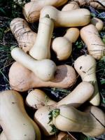 Butternut Squash- If there were justice, the butternut squash would be known as the Stow Butternut Squash, since it wasdeveloped by Stow farmer Charles Leggett at his property on Gleasondale Road in the 1940s. Leggett was looking for a squash that was more tender than a Hubbard and more efficient to ship than a Gooseneck. After he introduced it to scientists as the Waltham Field Station (who acknowledged his role) it was tagged as the Waltham Butternut. But it’s really the Stow Butternut Squash.
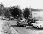 Fruit Acres- As the largest orchard in Stow for many years, Fruit Acres farmstand on Whitman Street attracted apple buyers from a wide area, as suggested by this photo from 1964. Today, the Fruit Acres property is the site of the Birch Hill Residential area.
 Alpacas- Once a town of 1,000 cows and multiple dairy farms, today Stow is home to a few cows, horses for recreational riding and more than a dozen alpacas at Springbrook Farm.
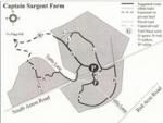 Conservation Land- The Captain Sargent Farm tract along West Acton Road is one of more than a dozen “conservation”lands preserved for public use within Stow’s borders. Nearly a quarter of the town is permanently protected as “open space.” Nathaniel Sargent was a Revolutionary War veteran who subsequently led a militia company that helped put down Shay’s Rebellion in Western Massachusetts in 1787.